Tasmania
 Launceston
Northeast of Tasmania, Launceston is a city with about 100 000 citizens, along river Tamar. Parts of the city are built on hills along the river.

 Cataract gorge is a superb place where the South Esk river has eroded the rock. There’s only a little water as there’s a dam upstream, there’s also a power station (the first in the southern hemisphere, built in 1895).


 After the first basin, the gorge narrows and is crossed by Alexandra suspension bridge, built on rock above a small cascade.
 Freycinet peninsula
On the east coast of Tasmania, Freycinet peninsula advances in the sea, it’s a big national park. Its name comes from a French navigator who explored Tasmania with the Nicolas Baudin expedition between 1800 and 1805.

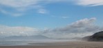
 North of the peninsula, Friendly Beaches includes big beaches of white sand scattered with boulders. The water is clear and blue-green. The sea polishes rounded boulders and washes the debris it left on the beach.
After the park entrance, you can reach the peninsula by walking over a rather steep pass between two of the four “Hazards”, mount Amos and mount Mayson. On the way, begging wallabies are not shy, and the track passes between huge rocks.

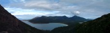 The ascent is rewarded by the view from the top of the pass: Wineglass bay and a superb panorama of the peninsula. You can then tumble down towards the beach or choose to climb mount Amos.
 Tasman peninsula
Southeast of Tasmania, the Tasman peninsula is a big territory linked to mainland Tasmania by the Eaglehawk Neck isthmus. It includes the former penitentiary colony of Port Arthur. It’s an excellent place for great walks, like the one leading to Cape Raoul:

 It starts by climbing through a forest to arrive at the edge of the cliffs, then you walk along these, and you can see other capes. After that you go down on a lower plateau, about half the height of the plateau you came from.


 The edge of the cape has dolerite columns profiled on the sea. On the way back, the clouds break on the cape.

 Hobart
Hobart is the capital of Tasmania, here are its buildings by night, including a pub proud of its age, and a brick chimney.


 Mount Field national park
Mount Field is a big national park southwest of Tasmania, where you can walk among tall trees, mainly gum trees, and meet wallabies.


 En bas de ce parc situé en montagne, les cascades comme Horseshoe falls et Russell falls dégringolent parmi les fougères, passant selon les pluies d’un mur à un filet d’eau.


 Donaghy’s hill lookout
Donaghy’s hill lookout allows to discover a landscape of gum tree forests, rivers and mountains.
 Nelson falls
Another short walk leads to Nelson falls, where light and water cascade down.
 Ocean’s beach
Ocean’s beach, a big empty beach on the western coast of Tasmania.


 Lake Rosebery
Lake Rosebery, northwest of Tasmania, is a dam lake where you can go canoeing. On the shore, you notice the vegetation dating from before the lake was filled, and the weather changes really fast.

 Cradle mountain
The Cradle Mountain national park is one of the most famous places in Tasmania, including several peaks like Cradle Mountain, and lakes like lake Dove. While I was there, the place was shrouded in clouds.


 In this climate, vegetation is lush, like these spinifex balls, trees looking almost pruned, and trunks glistening in the rain.


 To control trampling, a wooden path winds between spinifex bushes. Trees are covered in lichen and moss, and there are a few blooming banksia left.